Kallak - Iron Ore
Kallak benefits from excellent local infrastructure with all-weather gravel roads passing through the project and forestry tracks allowing for easy access throughout the licence. A major hydroelectric power station, with associated electric powerlines, is located only a few kilometres to the southeast. The nearest railway, the Inlandsbanan, passes approximately 40 km to the east. The Inlandsbanan meets the Malmbanan railway at Gällivare, which provides routes to the Atlantic harbour at Narvik in Norway or to the Bothnian Sea harbour at Luleå in Sweden.
Kallak was discovered by The Swedish Geological Survey (SGU) in the 1940s. The first exploration licence for Kallak was awarded by the Mining Inspectorate of Sweden in 2006. Drilling was conducted at Kallak North and South between 2010-2014, across a total of 131 holes and 27,895 metres (“m”).
On 25 May 2021, the Company published a ‘Mineral Resource Estimate and Exploration Target Upgrade’, prepared by Baker Geological Services (“BGS”). For Kallak North, a Measured and Indicated Resource of 111 Mt grading 28 % iron content was defined, with an additional Inferred Resource of 25 Mt grading 28.3 per cent iron.
For Kallak North and South combined, BGS derived a Measured and Indicated Mineral Resource of 132 Mt grading 27.8 % iron and an Inferred Mineral Resource of 39 Mt grading 27.1 % iron.
In the Kallak area, iron mineralisation in addition to the Mineral Resource, an Exploration Target between 73 Mt and 218 Mt grading between 20 % iron (Fe) to 30 % Fe, has also been defined. The potential quantity and grade are conceptual in nature as there has been insufficient exploration to date.
When it comes to sustainable mining in the north of Sweden, mines can be powered by renewable electricity, with the goal being ‘Net Zero’ mining operations. Kallak represents a potential source of high-quality iron ore for fossil-free steel making in Norrbotten for decades to come.
A September 2017 report by Copenhagen Economics titled ‘Kallak – A real asset, and a real opportunity to transform Jokkmokk’ highlighted the potential positive economic impact of the project on Jokkmokk, and Norrbotten County. Some key highlights:
- Kallak has the potential to create 250 direct jobs and over 300 indirect jobs in Jokkmokk, over the period that a mine is in operation.
- These jobs could be sustained over a period of 25 years or more.
- Kallak has the potential to generate SEK 1 billion in tax revenues, considering the case where 70 % of the mine’s workforce are based locally, with annual tax revenues of SEK 40 million over a 25-year mine life.
- These tax revenues would help to develop and sustain public services and infrastructure in Jokkmokk, which are at risk due to a lack of new investment and job creation in the community, a declining population, and an ageing population.
The study builds on the work carried out by the Company and others, including the 2015 independent socio-economic study initiated by Jokkmokks Kommun, completed by consultants Ramböll, and the 2010 study by the Economics Unit of Luleå University of Technology (LTU), ‘Mining Investment and Regional Development: A Scenario-based Assessment for Northern Sweden’. The socio-economic study initiated by Jokkmokks Kommun concluded that a mining development at Kallak would create direct and indirect jobs, increase tax revenues and slow down population decline. As well as revisiting the work done by Ramböll and LTU and reminding stakeholders of Kallak’s economic potential locally, regionally, and nationally, the study also details the Company’s philosophy on what needs to happen to ensure Kallak is a success, and that Jokkmokk maximises the benefits it receives.
Kallak is located within the Svecofennian shield, consisting of metamorphic, sedimentary and volcanic rocks that are commonly between 1,900 and 1,870 million years old. The area around Kallak is dominated by mafic to intermediate metavolcanics rocks, as well as gabbro, diorite, ultramafic rocks and their metamorphic equivalents. The iron deposits are outcropping and consist of quartz, banded magnetite haematite iron ore, comprised of fine grained magnetite and minor haematite, interlayered with quartz, feldspar and some hornblende. The dominant host rock is a grey altered volcanic unit.
The Kallak North and Kallak South orebodies are centrally located and cover an area approximately 3,700 m in length and 350 m in width, as defined by current drilling. The mineralised structures at both Kallak North and Kallak South are almost vertically dipping, generally covered by shallow glacial overburden and, as such, are highly amenable to open pit mining. The mineral resource estimate for Kallak North and South is based on drilling conducted between 2010-2014, with a total 27,895 m drilled in 131 drill holes. The latest resource statement for the Kallak project was finalised by Baker Geological Services Ltd (BGS) on the 25 May 2021, following the guidelines of the Pan-European Reserves and Resources Reporting Committee (PERC) Standard for Reporting of Exploration Results, Mineral Resources and Mineral Reserves. Summary as follows:
| Deposit | Classification | Million Tonnes | Density | Fe % | FeO % | SiO2 % | Al2O3 % | P % | S % |
|---|---|---|---|---|---|---|---|---|---|
| KN | Measured | 16 | 3.5 | 33.6 | 10.5 | 43.4 | 2.9 | 0.04 | 0.002 |
| Indicated | 95 | 3.3 | 27.0 | 7.1 | 49.8 | 4.5 | 0.03 | 0.002 | |
| Sub-Total | 111 | 3.3 | 28.0 | 7.6 | 48.9 | 4.3 | 0.03 | 0.002 | |
| Inferred | 24 | 3.4 | 28.3 | 7.8 | 48.1 | 4.2 | 0.04 | 0.002 | |
| KSN | Measured | ||||||||
| Indicated | 20 | 3.3 | 26.9 | 7.2 | 49.3 | 4.9 | 0.04 | 0.003 | |
| Sub-Total | 20 | 3.3 | 26.9 | 7.2 | 49.3 | 4.9 | 0.04 | 0.003 | |
| Inferred | 6 | 3.2 | 23.4 | 6.5 | 50.1 | 6.6 | 0.05 | 0.004 | |
| KSS | Measured | ||||||||
| Indicated | |||||||||
| Sub-Total | |||||||||
| Inferred | 8 | 3.3 | 26.1 | 12.0 | 50.1 | 5.2 | 0.05 | 0.009 | |
| Total | Measured | 16 | 3.5 | 33.6 | 10.5 | 43.3 | 2.9 | 0.04 | 0.002 |
| Indicated | 115 | 3.3 | 27.0 | 7.1 | 49.7 | 4.6 | 0.03 | 0.002 | |
| Sub-Total | 131 | 3.3 | 27.8 | 7.5 | 48.9 | 4.4 | 0.03 | 0.002 | |
| Inferred | 39 | 3.3 | 27.1 | 8.5 | 48.8 | 4.8 | 0.04 | 0.004 |
(1) Mineral Resources, which are not Mineral Reserves, have no demonstrated economic viability.
(2) The effective date of the Mineral Resource is 9 May 2021.
(3) The Open Pit Mineral Resource Estimate was constrained within lithological and grade-based solids and within an optimised pit shell defined by the following assumptions; base case metal price of USD130 / tonne for a 65% Fe concentrate; Fe recovery of 71% at Kallak North, 86% at Kallak South North and 94% at Kallak South South; Fe concentrate grades of 68% at Kallak North, 70% at Kallak South North and 69% at Kallak South South; Processing costs of USD6.8 / t wet; Selling cost of USD21.0 / t wet concentrate; Mining cost of Ore of USD3.3 / t, mining cost of waste of USD3.0 / t and an incremental mining cost per 10 m bench of USD0.05 / t; Wall angles of 30° within the overburden and 47.5° in the fresh rock.
(4) Mineral Resources have been classified according to the PERC Standards 2017, by Howard Baker (FAusIMM(CP)), an independent Competent Person as defined in the PERC Standard 2017.
In total, BGS has derived a Measured and Indicated Mineral Resource of 132 Mt grading 27.8 % iron (Fe), 7.5 % iron oxide (FeO), 48.9 % silicon dioxide (SiO2), 4.4 % aluminium oxide (Al2O3), 0.03 % phosphorous (P) and 0.002 % sulphur (S).
BGS has also defined an Inferred Mineral Resource of 39 Mt grading 27.1 % Fe, 8.5 % FeO, 48.8 % SiO2, 4.8 % Al2O3, 0.04 % P and 0.004 % S.
The pit optimisation undertaken shows a strip ratio of one ore tonne for every 1.22 waste tonne.
In addition to the Mineral Resource Estimate (“MRE”) upgrade, BGS has updated the Exploration Target for the Kallak project with inclusion of the Parkijaure permit area. In total, BGS has reported an Exploration Target of between 73 Mt and 218 Mt grading between 20 % Fe to 30 % Fe. The potential quantity and grade are conceptual in nature as there has been insufficient exploration to estimate a Mineral Resource; and that it is uncertain if further exploration will result in the estimation of a Mineral Resource.
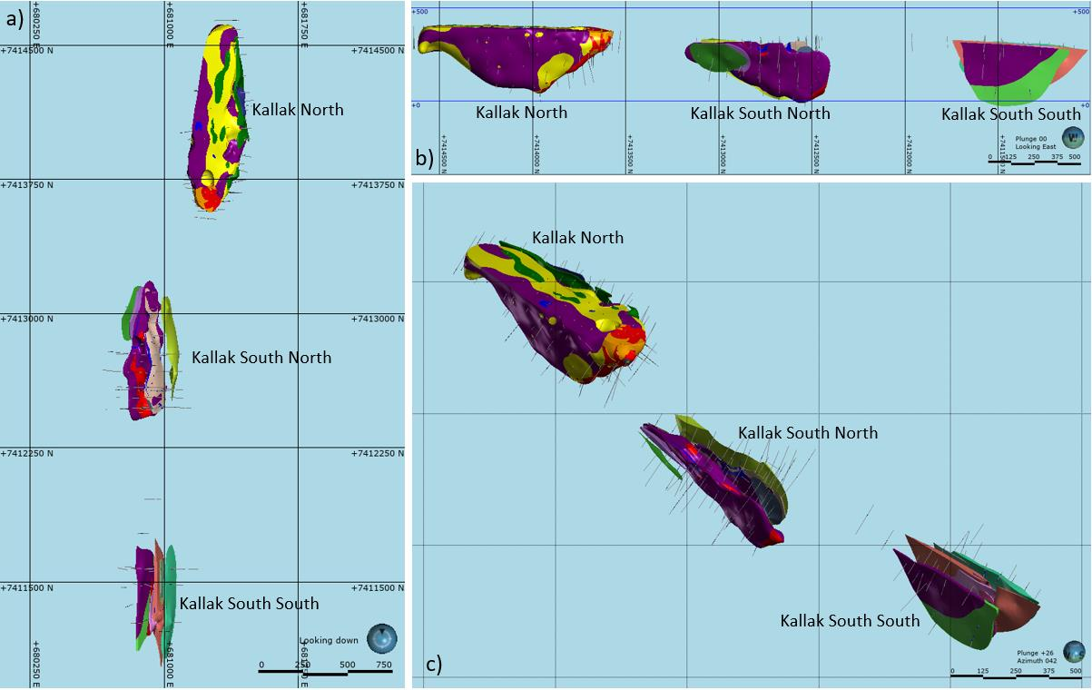 Locations of the KN, KSN and KSS targets. a) plan view, b) looking east, c) oblique view, looking northeast. Coloured by geological domain.
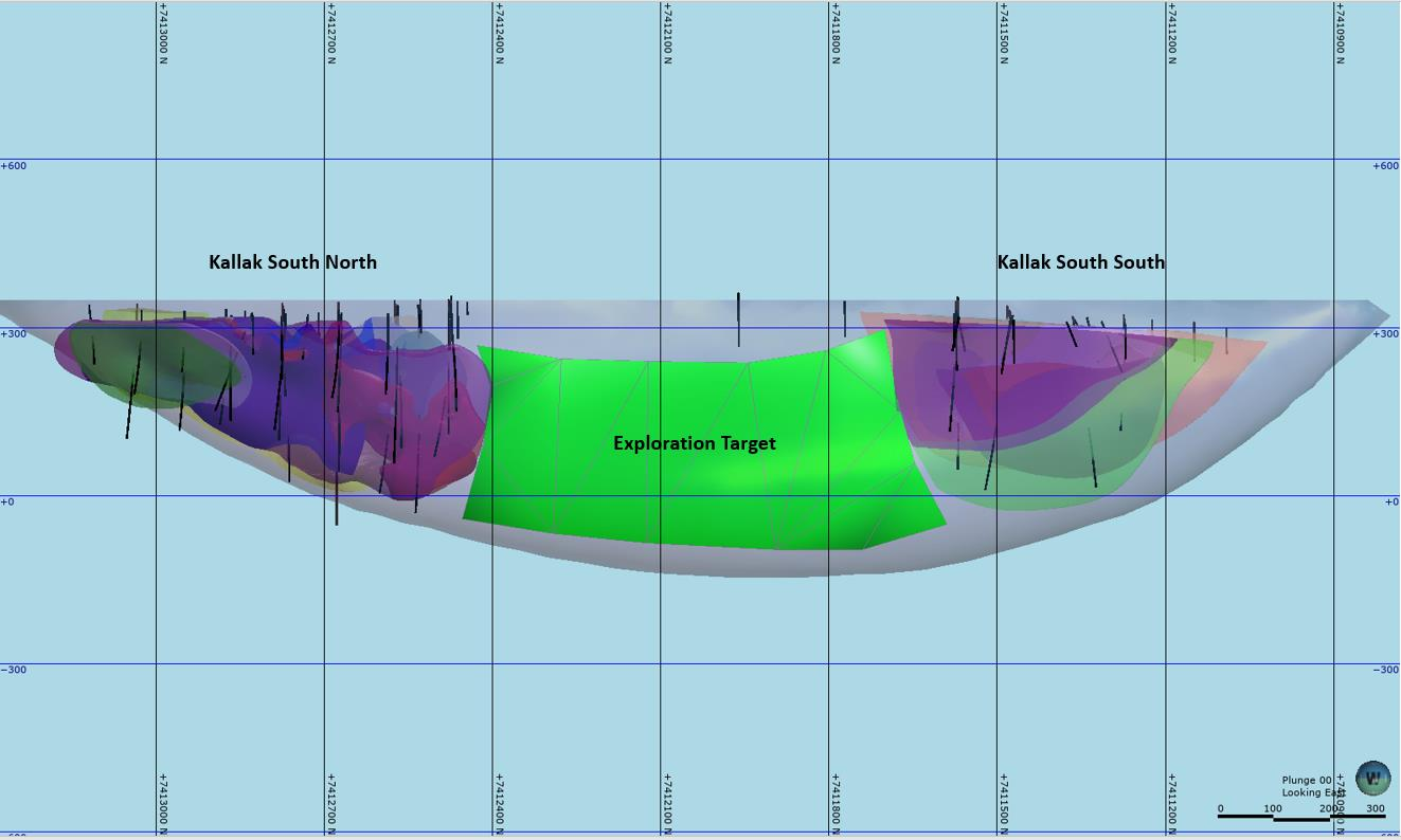
While external observers were expecting higher maiden resource tonnages for Kallak South, it is worth pointing out that the 2014 drilling programme for Kallak South focused on defining the potential extent of the orebody. The geophysical magnetic signature of mineralisation, evidence of the presence of magnetite, extends through the gap giving confidence for an exploration target, but insufficient drilling precludes any additional resource classification.
On 22 March 2022, the Minister of Enterprise and Innovation, The Government of Sweden announced the award of the Concession for Kallak North; attached to the decision were 12 conditions for the Company to comply with. The Company’s legal advisers have reviewed the Government’s decision and the conditions attached to it and are satisfied that, with respect to the conditions, they include matters the Company would naturally expect to address in project development and the Environmental Court process